Introduction
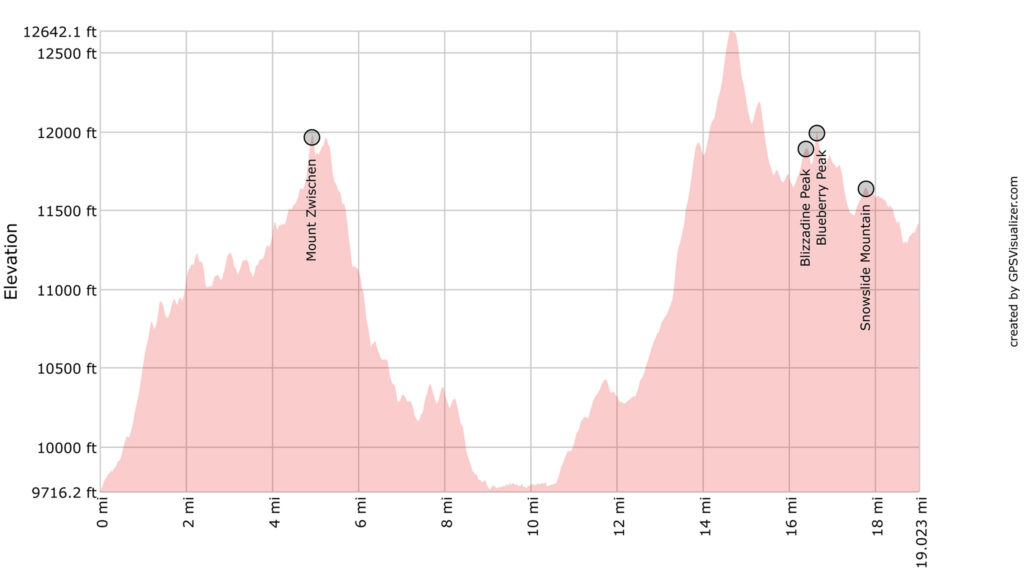
If Segment 1’s terrain over three 14ers and one Centennial left you reeling, Segment 2 will allow somewhat of a recovery. The first half is dominated by Mount Zwischen which seems like it should be an easy 12 mile jaunt, but holds many hidden difficulties. Getting to Medano Pass means crisp and clean running water. The rest of the route to Music should feel more like a walk in the park.
- 22.11 miles
- 8324′ gain
- 6623′ loss
Difficulty: Moderate — Class 1 trails and Class2+ bushwhacking, lack of water sources, blowdown, difficulty bailing.


Peaks Summited
- Mount Zwischen, 12,010′
- Blizzadine Peak, 11,922′
- Blueberry Peak, 12022′
- Snowslide Mountain, 11,672′
Getting There
A trail to Mosca Pass starts near the Great Sand Dunes Visitor Center. It’s 3.5 miles to the top of the pass.
This will be one of your first opportunities to leave a cache water/food and to drop off any climbing gear used. It’s not exceptionally convenient to do so, given it’s only accessible via foot or 4WD. But since it is relatively close to the Visitor’s Center, it could make a good spot to begin/end a section backpack of the route. You could call the local Alamosa taxi to inquire about service to the Great Sand Dunes National Park. It can be a hard hitch, as most of the visitors are out of State tourists, who aren’t in the frame of mind to pick up smelly backpackers.
Narrative
The 12 miles traversing Mount Zwischen to Medano Pass will hold little if no water, so do not start without adequate water in your pack (a few liters, at least).
Weather can be surprisingly hot, as you are at one of the low points of the entire ridge. There is no reasonable bailout off Zwischen to escape the mountain or to collect water. A seasonal stream is located to the west of the Mosca Pass, about a mile down.
Mount Zwischen’s charm is its semi-aridness, full of scrub brush and cacti. Its boulders and rocks seem particularly abrasive, and the soil is sandy. Large amounts of downed trees will have to be navigated.
0.0 Start up generally north towards the communication site. Use the road to the site if you would like, and you may also be able to find a social trail. Similar social and game trails will blip in and out of existence on this mountain and are generally found on or near the apex of the ridge.
1.15 A series of small high points will be needed to summit, with some loss of elevation. This gentle roller coaster of bumps will define your experience of Zwischen (along with the blowdown).
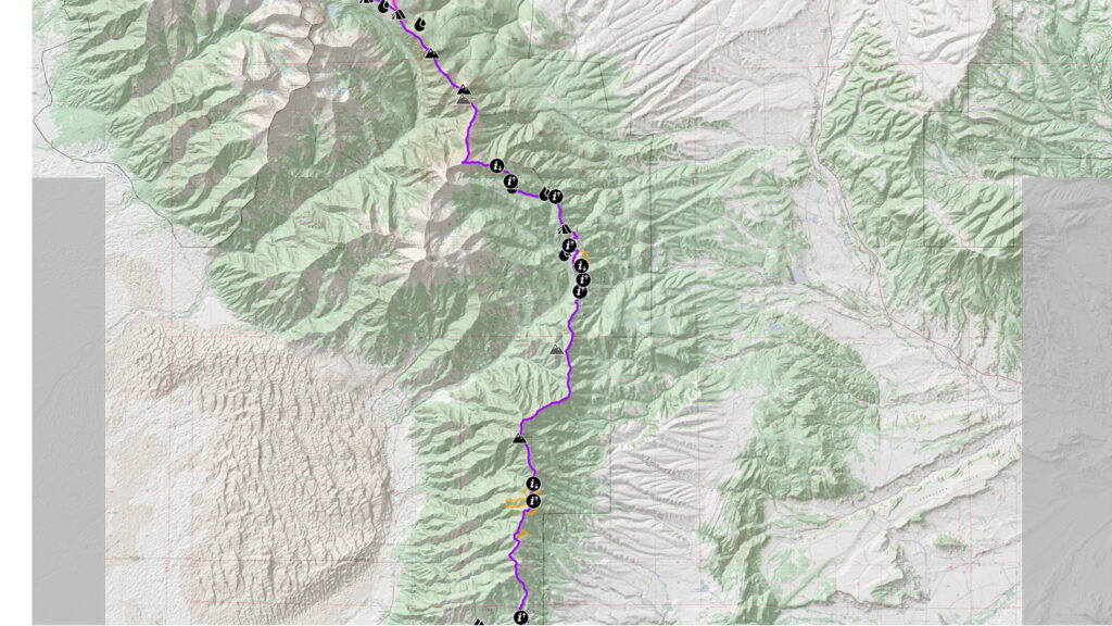
2.92 Elevation will stall out at around 11,000’ for about a mile before you hit one of the largest patches of blowdown you’ll find on the route — it can only be experienced to be believed. Generally, avoid much of blowdown by skirting east of the ridgeline. You’ll lose some hard-earned elevation, but going directly through the blowdown may prove impossible. See the map for labeled areas of this blowdown.
4.0 Once through, make sure you haven’t lost any gear (or your mind), and any cuts and scratches you’ve earned are simply superficial, then soldier on. The summit isn’t actually that far away!
4.93 Mount Zwischen. This unimpressive summit is worth visiting, if only to allow you to survey the route ahead and see your progress from behind. There are over 6 miles of Mount Zwischen left. Continue down the ridge.

5.33 Follow the main ridge by turn right heading NE.
9.0 At the low point, the forest will open up a bit, and another social trail should be easily found. This social trail will lead you right to the Medano Ditch, which skirts the ridgeline itself to the west.
Staying right on top of the ridgeline will lead you to more blowdown mixed in with quickly shooting up aspens: a nightmare combination. Walking the ditch will help save your sanity, even if it may be a little wet.
9.21 Turn left, heading north to take the ditch.
10.61 Come to the Medano Pass 4WD. Turn Left heading north.
If you’re desperately in need of water or a campsite, both can be found downhill to the southwest. Continue to crest the pass itself by walking northeast on the Medano Pass 4WD road.
10.94 Medano Pass. Turn left on another 4WD heading northwest. This road will follow the crest of the ridgeline for you and end at a parking lot next to the Hudson Ditch.
12.09 Hudson Ditch. Beyond this, turn left heading west and loosely follow the Hudson Branch of the Medano Creek for about a mile, a social trail should be found just to the north of the creek. Again, expect blowdown in this area. If the creek is running, this will be the very last free water source on route for many, many miles. Camel up!
13.3 Time to climb to the crest of the ridge once again. Find a social “trail” up the steep and very loose slope skywards heading north. This will not be a pleasant experience, but you’ll be happy to finally get to the ridgeline again.
13.86 Gain the ridge. Follow the ridgeline west.
14.7 Turn right to continue following it as it turns north.
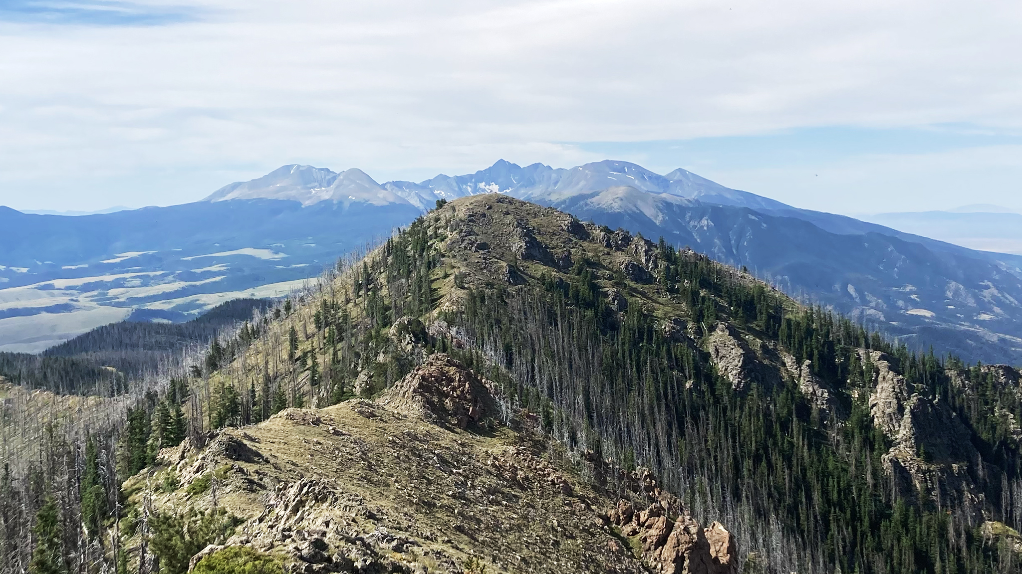
The next few peaks are easy walk ups on talus and tundra, although with great exposure from the sun. The going should feel relatively brisk, especially after Zwischen. You may even find yourself having fun.
16.43 Blizzadine Peak
16.69 Blueberry Peak
The ridge tightens up after Blueberry Peak and forest enters the picture towards Music Pass. Social trails may be found near the crest of the ridge. Be on the lookout for excellent views to the west over the Sand Creek Basin and towards Tjieras and Cleveland Peak. That ridgeline dominates the comparatively diminutive one you’re presently on, but it peters out down the northern end of the Grand Sand Dunes.
17.84 Snowslide Mountain
19.03 Music Pass. Bivvy opportunities present themselves, but the camp is dry and could be buggy. A spring may be available to the west down the Music Pass Trail.